
ACE Basin – 1860. The acronym stands for Ashepoo-Combahee-Edisto, three rivers in Colleton County, SC. The map is from Suzanne Linder’s Historical Atlas of the Rice Plantations of the ACE River Basin – 1860. (Click on the map to view it at full size.)
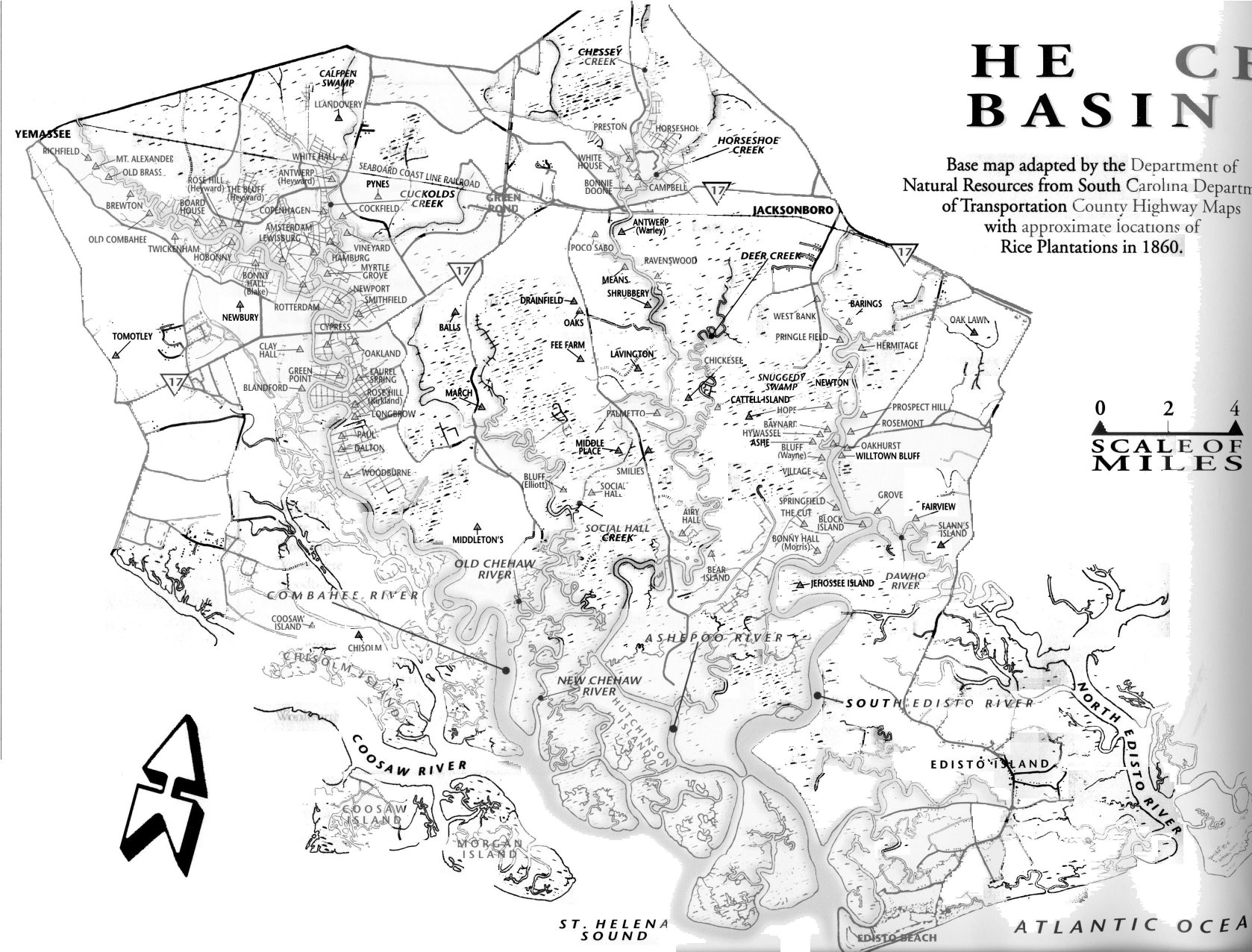
The ACE basin contained the Heyward family’s richest rice plantations. Daniel Heyward (b. 1720), great-grandson of the immigrant of the same name, called his Combahee River plantations his “gold mines.” They remained in the Heyward family until after the Civil War.
In 1860 the following plantations on the map were owned by men with the surname of Heyward: Amsterdam, Antwerp, Blanford, Bluff, Clay Hall, Cypress, Green Point, Hamburg, Lewisburg, Myrtle Grove, Pleasant Hill, Pynes, Rose Hill and Rotterdam. Two plantations, Hope and Prospect Hill, were owned by Edward Barnwell, husband of Margaret Manigault, a Heyward descendant.
The Hamburg plantation is noteworthy as a property once owned by James Heyward, brother of Nathaniel Heyward (b. 1766) and husband of Susan Cole, a woman of dubious reputation he had met in England. James died in 1796, shortly after his marriage. His will gave Susan Cole income from Hamburg as long as she lived, after which full ownership would go to Nathaniel Heyward. The Heywards never accepted Susan Cole and they resented this arrangement. Nevertheless, when Susan died in 1846, Nathaniel Heyward reclaimed Hamburg and turned over its management to his grandson James Barnwell Heyward (b. 1817), who planted rice there before and after the Civil War. For details of the Susan Cole story, go here.
Also notable on the map is Cypress, a plantation located at the point where Highway 17 now crosses the Combahee River. Abolitionist Harriet Tubman organized a US Army raid on Cypress on June 2, 1863. The raiders stole 199 slaves and set fire to the plantation owner’s fine home and furniture, other dwellings, rice mills, barns, and boats. The plantation owner, William Cruger Heyward, sought help from nearby Confederate soldiers but they were unable to save his property.
Cooper River – 1842. The map below is from A Day on Cooper River by John B. Irving, MD enlarged and edited by Louisa Cheeves Stoney, 1969. (Click on the map to view it at full size.)
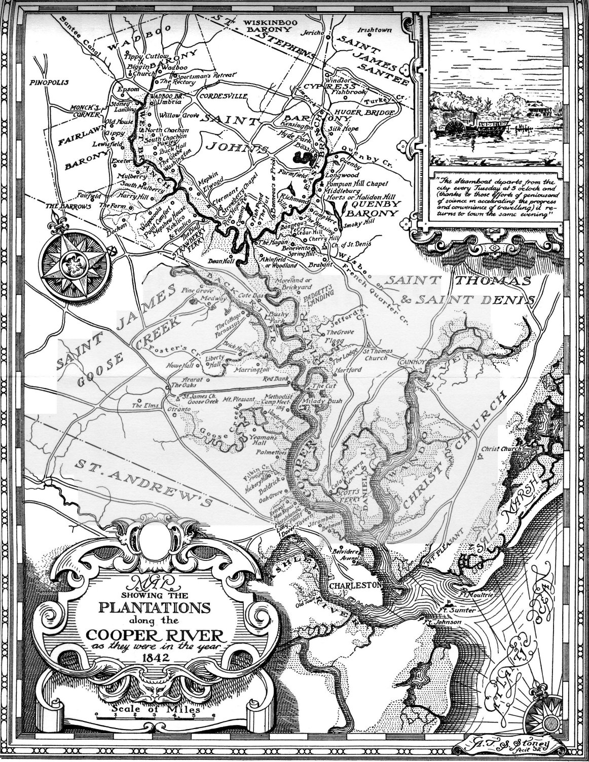
Some plantations shown on this map were owned by Heyward descendants.
Silk Hope and Marshlands – Owned by Nathaniel Heyward (b. 1766) in 1827. He passed them on to his youngest daughter Elizabeth and her husband Charles Manigault.
Wappaoola – Francis William Heyward (b. 1844) bought Wappaoola at auction about 1871 for $5,000. He planted rice there until his death in 1907.
Retreat – Owned by Wilson Glover (b. 1758) and later by his daughter Ann Heyward Glover (b. 1790).

Wilson Glover, husband of Margaret Heyward, also owned Fontainebleau on the backwaters of the Ashepoo River, and several plantations in “Indian Land” which was around Grahamville, SC.
Do you have any maps of the Glover land holdings in and around Bolan Hall Rd, Ridgeland, SC area? I am researching the history of several plantations in the area and are lacking maps of land holdings.